Bugzeye™ Drone Mapping and PhotographyServing all of Arizona(480) 953-0626

Services

Drone Land Surveyors

At Bugzeye Drone Mapping & Photography, our licensed land surveying services are crafted to meet the highest standards of accuracy and reliability. Using drones, our associated surveyors provide efficient land surveys tailored to meet a wide range of requirements for various industries. Whether surveying complex terrain, handling construction site planning, or ensuring precise lines, our associated surveyors ensure every detail is captured accurately and efficiently.

We want to make your project easier. Let us complete it quicker and for less.

Tell us about your project

Licensed Land Surveying

Data Collection for Advanced Drones

Our drones, equipped with advanced cameras and sensors, gather precise data on everything from land details to property measurements. For each project, our associated surveyors tailor data collection to the specific needs of the site and client, ensuring that deliverables meet all legal and regulatory requirements. This level of control and precision is especially critical for projects involving dangerous terrain or hard-to-reach areas, where traditional methods are less effective.

Expertise and In-House Processing for Accurate Deliverables

Our team of associated surveyors has extensive experience working across diverse locations and adapting to specific site conditions for accurate mapping and position of objects. This adaptability means we can handle everything from urban development plots to remote environmental studies, where our drones’ ability to reach previously inaccessible areas makes a significant difference in delivering an accurate representation. The quality of our land surveys is enhanced through in-house data processing. Our associated surveyors use specialized software to convert raw data into useful formats, such as orthomosaics and 3D models. These digital surface models are invaluable in construction planning, engineering, and real estate development, offering detailed insights that clients can rely on. By handling every step in-house, from initial flights to data analysis, Bugzeye maintains complete control over quality, ensuring our clients receive accurate, actionable data for every project.

Aerial Surveying (AKA) Drone Surveying Methods

Aerial surveying with drones has revolutionized land surveys across industries. At Bugzeye, our drones are equipped with high-resolution cameras and advanced sensors, enabling them to capture extensive data on terrain, structures, and more in a fraction of the time required by traditional methods. Our aerial surveying process begins with an in-depth consultation, where we assess the location, define project goals, and identify any unique requirements.

Accessing Challenging Terrain

Using drone aerial vehicles for aerial surveying allows us to access hard-to-reach areas, complex terrain, and large plots of land. Our associated surveyors plan all flight lines meticulously, balancing drone flights with any necessary ground-based surveys to ensure every critical detail is captured. This includes gathering high-resolution images, measurements, and data points needed for 3D models, orthomosaics, and land maps. Aerial surveying with drones is particularly beneficial for construction projects where accuracy, speed, and flexibility are essential.

++++++++

Data Processing

Our associated, professional land surveyors rely on specialized software that can process extensive datasets quickly and accurately. The software we use allows us to convert raw images into high-quality deliverables, providing actionable insights for a wide range of industries. Our drones provide instant, real-time data and our teams utilize specialized software to process data in-house, creating precise models and maps that meet the rigorous requirements of industries such as engineering, real estate, and environmental survey management. This approach combines the speed of aerial surveys with traditional methods, making it ideal for projects requiring detailed land surveys, topographic mapping, or complex measurements.

High-Resolution Aerial Imagery

In addition, we also offer aerial imagery services with high-resolution, detailed, drone imagery. Should your project require aerial images, our professional aerial photography services are here to deliver exactly what you need.

Contact Us to Learn More

Steps for Successful Drone Surveys

Achieving accurate, reliable drone surveys involves a well-defined process that combines expertise, technology, and quality control. Here are the essential steps our pilots and associated surveyors follow:

    1. Initial Consultation and Project Assessment: Each project starts with a consultation to understand its specific goals, deliverables, and requirements. We evaluate the location and determine if there are any unique considerations, such as municipal and FAA regulations, safety, dangerous terrain, complex terrain, or hard-to-reach areas that may impact flights or data collection.
    2. Site Planning and Preparation: Our pilots and associated surveyors prepare for the survey by mapping out flight paths, and property lines, setting up drones with the necessary cameras and sensors, and identifying key data points or drone images to capture. This step ensures the data gathered will meet both the project's immediate needs and any regulatory requirements.
    3. Flight and Data Capture: Using high-resolution cameras and sensors, our drones gather images and measurements across the site. Depending on the size and complexity of the location, flights may be completed within a day or span multiple sessions. These flights provide high-quality data used to build accurate maps, models, and orthomosaics.
    4. Data Processing and Analysis: Once data is captured, our in-house team processes it using advanced software. This step converts raw images and measurements into deliverables in formats such as 3D models and orthomosaics, which clients can use for planning and analysis.
    5. Quality Control and Final Deliverables: Licensed surveyors conduct a quality control review to ensure accuracy, completeness, and compliance with all requirements. We can provide clients with final deliverables in various formats, ensuring each output is ready for immediate application in construction, engineering, or other fields.

Each step in this process is tailored to the specific needs of our clients and is overseen by professional surveyors who ensure that data meets the highest standards of accuracy. This approach allows us to deliver not only comprehensive measurements but also the dependability clients need for informed decision-making in their respective industries.

Construction Surveying with Drones

Drones have become essential tools for construction surveying, offering fast, accurate, and versatile solutions for site assessments and ongoing project management. Bugzeye’s construction mapping services use drones to capture detailed terrain data, generate 3D models, and produce orthomosaics that provide a full overview of the site. These tools allow construction managers, architects, and engineers to visualize site conditions and manage resources effectively.

Efficient Land Surveys

Using drones allows the survey of large plots of land and hard-to-reach areas without extensive on-ground labor, which significantly reduces costs and project timelines. Our associated surveyors capture accurate measurements of land, terrain contours, and existing structures. This data is crucial for construction planning, enabling teams to identify potential obstacles and ensure accurate positioning of new structures.

Detailed Visual Tools for Construction

Drones equipped with high-quality cameras and sensors gather a wealth of information in each flight. This data is processed into detailed formats, such as 3D models and orthomosaics that support site planning, construction monitoring, risk assessment, and quality control. These visual tools also help construction teams track progress, detect outliers, and make data-driven decisions on the go. Bugzeye’s construction mapping meets the needs of diverse industries and is customized for the unique requirements of each project.

Learn more on our Construction Page.

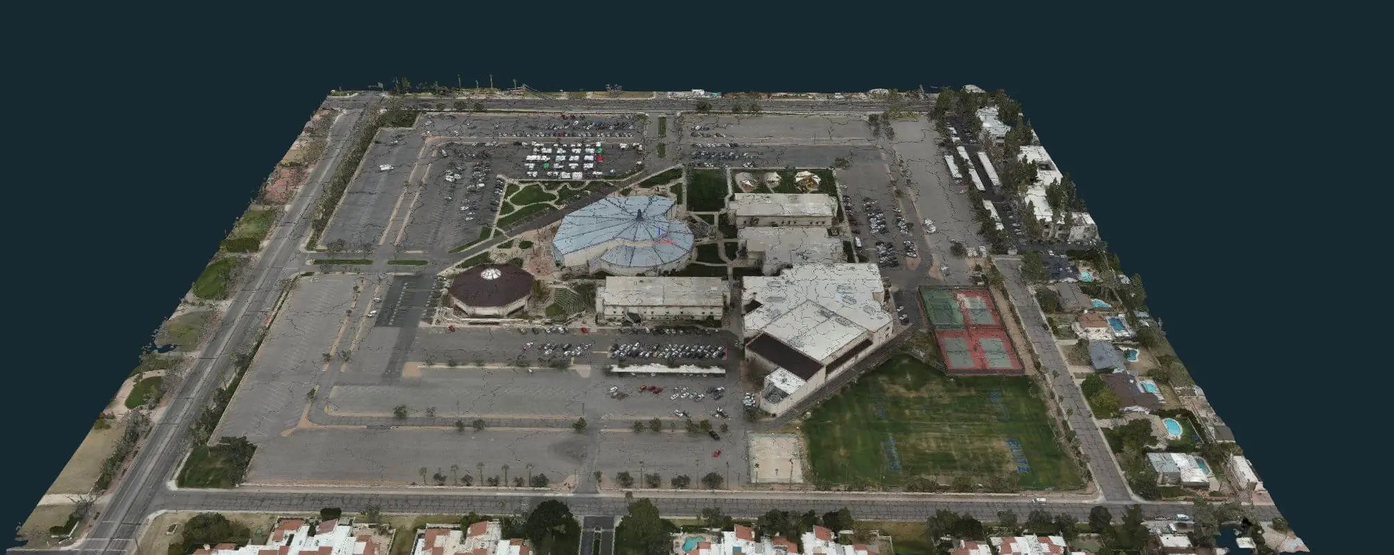
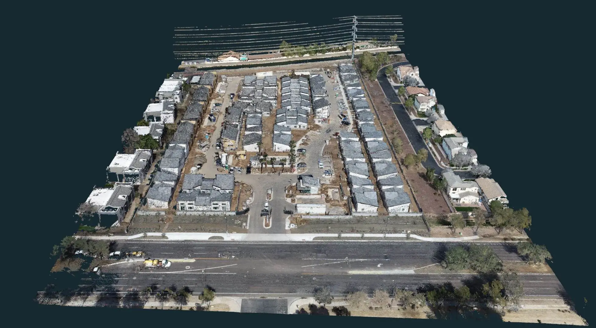
3D Mesh Model
3D Mesh Model
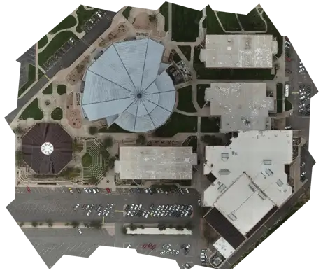
3D Orthomosaic Photo
++++++++

Drone Land Surveys & Measurements

Drones have become essential tools for construction monitoring and verification, offering fast, accurate, and versatile solutions for site assessments and ongoing project management. Bugzeye's construction imaging and mapping services use drones to capture detailed terrain data for topographic surveys, generate 3D models, and produce orthomosaics that provide a full overview of the site. These tools allow construction managers, architects, and engineers to visualize site conditions and manage resources effectively.

Lower Cost, Faster Deliverables, Better Data

By using drones, we can map large plots of land and hard-to-reach areas without extensive on-ground labor, which reduces costs and project timelines. Our associated surveyors capture accurate measurements of land, terrain contours, and existing structures. This data is crucial for construction planning, enabling teams to identify potential obstacles and ensure accurate position of new structures.

Absolute "Game-Changer" for Construction & Other Industries

Drones equipped with high-quality cameras and sensors gather a wealth of information in each flight. This data is processed into detailed formats, such as 3D models and orthomosaics, that support site planning, risk assessment, and quality control. These visual tools also help construction teams track progress, detect outliers, and make data-driven decisions on the go. Bugzeye's construction imaging and mapping meets the needs of diverse industries and is customized for the unique requirements of each project.

Tell Us about Your Project

Traditional Land Surveying vs Drone Surveys

Traditional methods of land surveying have long been essential for capturing detailed data on the property, topography, and infrastructure. However, drones have introduced a level of efficiency and flexibility that traditional methods cannot match. At Bugzeye, we understand both traditional methods and drone-based aerial surveys, combining the intimate knowledge of each to provide optimal solutions for our clients.

Surveying Large or Complex Sites

Traditional methods involve on-ground measurements and are typically labor-intensive. They are best suited for small sites or where precise on-ground detail is necessary and can be handled relatively easily by a small crew. However, these methods are not ideal for large sites, complex terrain, or hard-to-reach areas, where land or topographic mapping with drones is far more effective. Drones allow us to gather extensive data across both small and large plots of land, and in difficult positions, reducing time and labor requirements without compromising accuracy.

Highly-Advanced Data Collection for Every Need

Our drones, equipped with cameras, sensors, and GPS technology, capture high-resolution images and data that our team processes into orthomosaics, 3D models, and site maps. This data is particularly useful in the construction process, real estate, and other industries that require high-speed, accurate data. With expert knowledge in both traditional and drone surveying methods, Bugzeye can adapt to the specific needs of each project, whether it’s a small lot or a multi-acre commercial site, we provide affordable, fast and accurate drone services to meet those needs.

Learn more on our Land Surveying Page.

Cost of Bugzeye Drone Surveys

Bugzeye's drone mapping offers a cost-effective alternative to traditional surveying methods. By using drones, we reduce the time, labor, and equipment costs associated with ground-based locating, making high-quality data accessible for projects of all sizes. Our flexible pricing model allows us to meet the needs of clients across a range of industries, from residential developments to large-scale industrial projects.

Project-Based Pricing for Your Needs & Budget

Our pricing is tailored to each project's specifics, such as the land size, location, and required deliverables. By keeping data processing in-house, we maintain strict quality control and pass on savings to our clients. We can provide deliverables in various formats, from orthomosaics to 3D models, ensuring each client receives actionable data suited to their needs. For ongoing projects, such as construction sites that require regular updates, we offer package options to align with project timelines and budget requirements.

Affordable, Precise Data

Bugzeye's commitment to affordability and quality means that our drone datasets provide reliable data without the high costs often associated with traditional surveying methods. Each dataset is customized to meet the requirements of the client's industry, delivering precise data that supports efficient and informed decision-making.

Set up a Consultation

Software and Systems Used for Drone Data Processing

Advanced Software Precision

Advanced Software Precision

The software we use is equipped to manage extensive datasets, process complex terrain features, and ensure that the output is accurate, consistent, and clear. Each orthomosaic and 3D model generated through our systems is reviewed for quality, ensuring that even the smallest details—such as land conditions, lines, and positions—are correct and meet client specifications. This accuracy is critical in projects requiring precise location mapping.

Ensuring Data Integrity

Ensuring Data Integrity

Our software also enhances the quality of data by filtering out any outliers, maintaining the integrity of the results. These systems allow us to adjust data formats to meet unique client requirements, whether they need detailed 3D models for construction planning or simplified orthomosaics for real estate development. Each piece of software is operated by experienced personnel, who have been trained extensively in both data processing and quality control, ensuring that every deliverable meets the highest standards.

Quick Turnaround Solutions

Quick Turnaround Solutions

Bugzeye's software systems also support quick turnaround times, which is crucial for projects that need frequent updates or where decisions are time-sensitive. Our team can rapidly process the data from drone flights, converting it into a format that is ready for immediate use by landowners, construction companies, urban planners, or environmental consultants. By handling all aspects of data processing in-house, we provide control over quality and confidentiality, and maintain the highest standards of accuracy.

++++++++++++

Handling Complex Location Details

For large and complex locations, our software systems are invaluable. They allow us to manage vast amounts of data collected from multiple flights, stitch together imagery seamlessly, and generate orthomosaics and maps that offer clear views of even the most intricate site details. Additionally, the software we use includes tools for creating 3D models, which can be manipulated to show various angles and perspectives, giving clients a comprehensive understanding of the surveyed area.

Reliable Results - Formatted to Your Needs

Bugzeye's commitment to using the latest software and systems reflects our dedication to delivering reliable, precise, and actionable data. By integrating cutting-edge technology with the knowledge of licensed surveyors, we ensure every client receives data that is formatted to their specifications and ready for application across a wide range of industries. Whether working with complex terrain, hard-to-reach areas, or multi-acre plots of land, Bugzeye's software systems and experienced team provides clients with data they can depend on for all their mapping needs.

Tell us about your project